Make a donation
Gear up for your next adventure:
As an Amazon Associate, this site earns from qualifying purchases at no extra cost to you.
Regents Park - Clyde
Interactive trail map
Make a donation
Gear up for your next adventure:
As an Amazon Associate, this site earns from qualifying purchases at no extra cost to you.
Trail profile
- Distance: 7.7 Km
- Elevation gain: 18 m
- Maximum elevation: 35 m
- Elevation loss: 43 m
- Minimum elevation: 6 m
Make a donation
Gear up for your next adventure:
As an Amazon Associate, this site earns from qualifying purchases at no extra cost to you.
About this trail
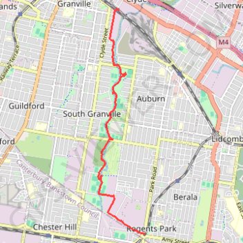
Name: Regents Park - Clyde trail, distance, elevation, map, profile, GPS track
Coordinates: -33.88324 151.01224 -33.83574 151.02396
Topography: Sydney topographic map, elevation, terrain
Make a donation
Gear up for your next adventure:
As an Amazon Associate, this site earns from qualifying purchases at no extra cost to you.
Other hiking, mountain biking, running and outdoor activity trails
Click on a trail to view its statistics, map and profile.
Sydney to Oran Park NSW
Australia > New South Wales > Sydney
Distance: 60.3 Km • Elevation gain: 577 m • Maximum elevation: 126 m
Auburn Circle
Australia > New South Wales > Sydney
Distance: 27.8 Km • Elevation gain: 108 m • Maximum elevation: 37 m