Mount Washington Trail in Mount Baker-Snoqualmie National Forest
The Mount Washington Trail offers a challenging yet rewarding hike through lush forests and rocky ridges. As you ascend, the dense canopy gives way to open vistas, revealing dramatic views of nearby peaks and valleys, including occasional glimpses of Mount Rainier. The final stretch provides a rugged but invigorating climb, rewarding hikers with sweeping panoramas of the Cascade Range, the Cedar River Watershed and the Snoqualmie Valley, making the effort worthwhile for those seeking both tranquility and adventure. #Hiking #Mountain #Forest #Nature #Overlook
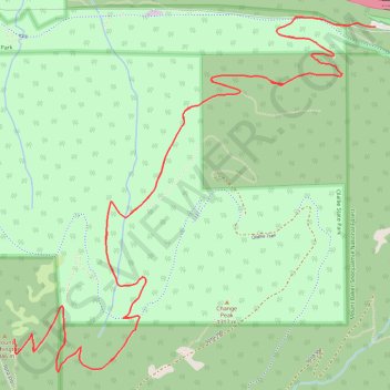
- Distance: 12.9 Km
- Elevation gain: 1,029 m
- Maximum elevation: 1,317 m
- Elevation loss: 1,026 m
- Minimum elevation: 386 m
Interactive trail map
Trail profile
- Distance: 12.9 Km
- Elevation gain: 1,029 m
- Maximum elevation: 1,317 m
- Elevation loss: 1,026 m
- Minimum elevation: 386 m
About this trail
Name: Mount Washington Trail in Mount Baker-Snoqualmie National Forest trail, distance, elevation, map, profile, GPS track
Coordinates: 47.42410 -121.69933 47.44214 -121.67230
Other hiking, mountain biking, running and outdoor activity trails
Click on a trail to view its statistics, map and profile.
Northern part of the Pacific Crest Trail (PCT)
United States > Oregon > Klamath County
Hike on the Pacific Crest National Scenic Trail from Crater Lake to Canada Border through Oregon and Washington along the Sierra Nevada and Cascade mountain ranges. #Hiking #Mountain #SierraNevada #Cascade #Nature #Forest #Park #PCT
Distance: 1,198.3 Km • Elevation gain: 44,308 m • Maximum elevation: 2,307 m