
Inspiration Point via Tunnel Trail and Inspiration Point Trail in Los Padres National Forest
The Inspiration Point hike via the Tunnel Trail offers a relatively moderate adventure through the beautiful landscapes of Los Padres National Forest. The route, starting at Tunnel Road, is a combination of shaded chaparral and rocky terrain as you ascend to a prominent overlook. Along the way, you'll be treated to sweeping vistas of Santa Barbara, the Pacific Ocean, and, on clear days, the Channel Islands in the distance, with jagged Mission Crags adding drama to the views. The hike is popular for its panoramic views, making it especially enjoyable at sunrise or sunset. #Hiking ##Forest #Nature #Overlook #Pacific #Ocean #Sea
- Distance: 5.8 Km
- Elevation gain: 331 m
- Maximum elevation: 548 m
- Elevation loss: 371 m
- Minimum elevation: 268 m
Interactive trail map
Trail profile
- Distance: 5.8 Km
- Elevation gain: 331 m
- Maximum elevation: 548 m
- Elevation loss: 371 m
- Minimum elevation: 268 m
About this trail
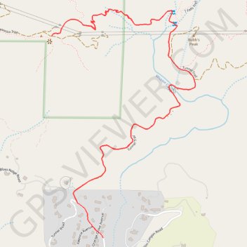
Name: Inspiration Point via Tunnel Trail and Inspiration Point Trail in Los Padres National Forest trail, distance, elevation, map, profile, GPS track
Coordinates: 34.46262 -119.71416 34.47343 -119.70594