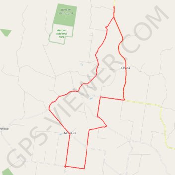
Mondure to Windera Park
Mondure, Silverleaf, Warnung, Cloyna, Kitoba, Windera, Glenrock
- Distance: 55.8 Km
- Elevation gain: 324 m
- Maximum elevation: 307 m
- Elevation loss: 324 m
- Minimum elevation: 213 m
- Moving time: 2 h 52 m
- Moving speed: 19.3 Km/h
- Maximum speed: 43.1 Km/h
- Total time: 3 h 30 m
- Global speed: 15.9 Km/h
Interactive trail map
Trail profile
- Distance: 55.8 Km
- Elevation gain: 324 m
- Maximum elevation: 307 m
- Elevation loss: 324 m
- Minimum elevation: 213 m
- Moving time: 2 h 52 m
- Moving speed: 19.3 Km/h
- Maximum speed: 43.1 Km/h
- Total time: 3 h 30 m
- Global speed: 15.9 Km/h
About this trail
Name: Mondure to Windera Park trail, distance, elevation, map, profile, GPS track
Start: Farrers Road, Mondure, South Burnett Regional, Queensland, Australia (-26.21762 151.76939)
End: Farrers Road, Mondure, South Burnett Regional, Queensland, Australia (-26.21768 151.77033)
Coordinates: -26.22047 151.74942 -26.03955 151.84553
Topography: Queensland topographic map, elevation, terrain
Other hiking, mountain biking, running and outdoor activity trails
Click on a trail to view its statistics, map and profile.
Ficks Crossing to Hivesville
Australia > Queensland > Wheatlands
Ficks Crossing, Wheatlands, Silverleaf, Marshlands, Hivesville, Leafdale, Keysland, Chelmsford, Queensland
Distance: 54.6 Km • Elevation gain: 395 m • Maximum elevation: 433 m
Ficks Crossing to Mount McEuen Queensland
Australia > Queensland > Ficks Crossing
Ficks Crossing, Wheatlands, Vhelmsford, Leafdale, Keysland, Mt McEuen, Fairdale, Queensland
Distance: 46.4 Km • Elevation gain: 401 m • Maximum elevation: 417 m
Murgon to Cloyna via Boat Mountain
Australia > Queensland > Murgon
Murgon, Tablelends, Merlwood, Warnung, Cloyna, Byee, Barlil, Queensland
Distance: 53.0 Km • Elevation gain: 651 m • Maximum elevation: 512 m
Byee to Greenview, Cushnie and Mondure
Australia > Queensland > Byee
Distance: 55.2 Km • Elevation gain: 381 m • Maximum elevation: 469 m
Wheatlands to Wooroonden
Australia > Queensland > Wheatlands
Wheatlands, Byee, Silverleaf, Wooroonden, Marshlands, Mondure, Queensland
Distance: 42.6 Km • Elevation gain: 180 m • Maximum elevation: 308 m
Leafdale to Stonelands
Leafdale, Mondure, Marshlands, Wooroonden, Stonelenda, Hivesville, Keysland, Queensland
Distance: 45.1 Km • Elevation gain: 354 m • Maximum elevation: 434 m
Murgon to Byee and back via Merlwood
Australia > Queensland > Murgon
Distance: 40.7 Km • Elevation gain: 352 m • Maximum elevation: 352 m
Byee Wheatlands
Byee, Wheatlands, Ficks Crossing, Queensland
Distance: 24.5 Km • Elevation gain: 101 m • Maximum elevation: 345 m