Kingaroy Heights, Usher Hill
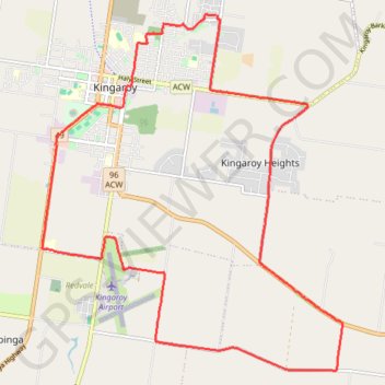
Kingaroy, Coolabunia, Queensland
- Distance: 27.2 Km
- Elevation gain: 311 m
- Maximum elevation: 565 m
- Elevation loss: 310 m
- Minimum elevation: 417 m
Interactive trail map
Trail profile
- Distance: 27.2 Km
- Elevation gain: 311 m
- Maximum elevation: 565 m
- Elevation loss: 310 m
- Minimum elevation: 417 m
About this trail
Name: Kingaroy Heights, Usher Hill trail, distance, elevation, map, profile, GPS track
Coordinates: -26.59490 151.82401 -26.52754 151.88757
Topography: Queensland topographic map, elevation, terrain
Other hiking, mountain biking, running and outdoor activity trails
Click on a trail to view its statistics, map and profile.
Kingaroy Taabinga Boonenne trace
Australia > Queensland > Kingaroy
Loop bike around Kingaroy. #Bike #Loop #Countryside #Nature #Forest
Distance: 36.8 Km • Elevation gain: 368 m • Maximum elevation: 542 m
Murgon - Kingaroy
Australia > Queensland > Murgon
#Bike
Distance: 48.4 Km • Elevation gain: 335 m • Maximum elevation: 489 m
Ushers Hill and Archookoora State Forest loop
Distance: 52.6 Km • Elevation gain: 655 m • Maximum elevation: 563 m
Kingaroy to Goodger Queensland
Australia > Queensland > Kingaroy
Goodger, Taabinga, Kingaroy, Boonenne, Queensland
Distance: 38.4 Km • Elevation gain: 300 m • Maximum elevation: 542 m
Memerambi - Corndale loop
Australia > Queensland > Kingaroy
Memerambi, Corndale, Booie, Kingaroy, Queensland
Distance: 45.5 Km • Elevation gain: 557 m • Maximum elevation: 569 m
Booie and Schellbachs Road near Kingaroy
Australia > Queensland > Kingaroy
Distance: 23.2 Km • Elevation gain: 356 m • Maximum elevation: 591 m
Kingaroy to Coolabunia and Ushers Hill
Australia > Queensland > Kingaroy
Distance: 39.7 Km • Elevation gain: 459 m • Maximum elevation: 565 m
Booie and Crawford, Qld Aus
Australia > Queensland > Kingaroy
Booie, Crawford, Kingaroy, Queensland
Distance: 38.1 Km • Elevation gain: 496 m • Maximum elevation: 569 m
Memerambi to Ushers Hill
Memerambi, Crawford, Kingaroy, Taabinga, Queensland
Distance: 47.1 Km • Elevation gain: 332 m • Maximum elevation: 567 m
Taabinga and Wattle Grove
Australia > Queensland > Kingaroy
Kingaroy, Taabinga, Inverlaw, Wattle Grove
Distance: 54.3 Km • Elevation gain: 474 m • Maximum elevation: 542 m
Booie and Jorgensens Road
Australia > Queensland > Kingaroy
Distance: 33.4 Km • Elevation gain: 405 m • Maximum elevation: 591 m
Kingaroy - East Wooroolin
Australia > Queensland > Kingaroy
Distance: 42.6 Km • Elevation gain: 495 m • Maximum elevation: 566 m
Coolabunia, Ushers Hill
Australia > Queensland > Kingaroy
Distance: 40.1 Km • Elevation gain: 488 m • Maximum elevation: 567 m
Memerambi
Australia > Queensland > Kingaroy
West side Memerambi and Crawford
Distance: 37.9 Km • Elevation gain: 294 m • Maximum elevation: 558 m
Booie loop
Australia > Queensland > Kingaroy
Booie, Kingaroy, Sandy Ridges, Queensland
Distance: 47.7 Km • Elevation gain: 511 m • Maximum elevation: 569 m