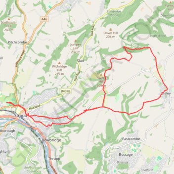
Stroud trigs
- Distance: 18.6 Km
- Elevation gain: 526 m
- Maximum elevation: 270 m
- Elevation loss: 522 m
- Minimum elevation: 46 m
- Moving time: 3 h 40 m
- Moving speed: 5.1 Km/h
- Maximum speed: 10.0 Km/h
- Total time: 4 h 36 m
- Global speed: 4.0 Km/h
Interactive trail map
Trail profile
- Distance: 18.6 Km
- Elevation gain: 526 m
- Maximum elevation: 270 m
- Elevation loss: 522 m
- Minimum elevation: 46 m
- Moving time: 3 h 40 m
- Moving speed: 5.1 Km/h
- Maximum speed: 10.0 Km/h
- Total time: 4 h 36 m
- Global speed: 4.0 Km/h
About this trail
Name: Stroud trigs trail, distance, elevation, map, profile, GPS track
Coordinates: 51.74142 -2.22754 51.76831 -2.14008
Other hiking, mountain biking, running and outdoor activity trails
Click on a trail to view its statistics, map and profile.
Laurie Lee Wildlife Way
United Kingdom > England > Gloucestershire > Painswick > Ham Butts
Distance: 15.0 Km • Elevation gain: 510 m • Maximum elevation: 215 m
Five Valleys Loop Walk
United Kingdom > England > Gloucestershire > Stroud > Randwick
Distance: 34.2 Km • Elevation gain: 907 m • Maximum elevation: 253 m
Toadsmoor Valley
United Kingdom > England > Gloucestershire > Nailsworth > Box
Distance: 31.4 Km • Elevation gain: 839 m • Maximum elevation: 236 m
Painswick east loop
United Kingdom > England > Gloucestershire > Painswick > Ham Butts
Distance: 13.0 Km • Elevation gain: 484 m • Maximum elevation: 215 m
NW to Stroud
United Kingdom > England > Gloucestershire > Nailsworth > Inchbrook
Stroud Walking
Distance: 19.2 Km • Elevation gain: 451 m • Maximum elevation: 200 m
Dean2023-311
United Kingdom > England > Oxfordshire > Oxford
Distance: 310.3 Km • Elevation gain: 3,366 m • Maximum elevation: 290 m
Stroud North loop
United Kingdom > England > Gloucestershire > Stroud > Selsley
Distance: 14.5 Km • Elevation gain: 349 m • Maximum elevation: 223 m
Stroud direct
United Kingdom > England > Gloucestershire > Nailsworth > Box
Distance: 16.2 Km • Elevation gain: 301 m • Maximum elevation: 205 m
Five Valleys
United Kingdom > England > Gloucestershire > Stonehouse > Leonard Stanley
Distance: 38.1 Km • Elevation gain: 882 m • Maximum elevation: 253 m