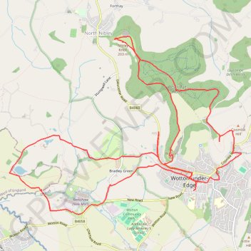
Wotton NM
- Distance: 18.8 Km
- Elevation gain: 377 m
- Maximum elevation: 205 m
- Elevation loss: 375 m
- Minimum elevation: 30 m
- Moving time: 3 h 54 m
- Moving speed: 4.8 Km/h
- Maximum speed: 10.5 Km/h
- Total time: 5 h 12 m
- Global speed: 3.6 Km/h
Interactive trail map
Trail profile
- Distance: 18.8 Km
- Elevation gain: 377 m
- Maximum elevation: 205 m
- Elevation loss: 375 m
- Minimum elevation: 30 m
- Moving time: 3 h 54 m
- Moving speed: 4.8 Km/h
- Maximum speed: 10.5 Km/h
- Total time: 5 h 12 m
- Global speed: 3.6 Km/h
About this trail
Name: Wotton NM trail, distance, elevation, map, profile, GPS track
Coordinates: 51.63291 -2.39771 51.65928 -2.34222
Other hiking, mountain biking, running and outdoor activity trails
Click on a trail to view its statistics, map and profile.
Tyndale Monument loop from Wotton-under-Edge via Westridge Wood, Nibley Knoll and Wotton Hill in the Cotswolds National Landscape
United Kingdom > England > Gloucestershire > Wotton-under-Edge
The Tyndale Monument loop offers a delightful hiking experience through the scenic landscapes of the Cotswolds, featuring a mix of woodland trails, rolling hills, and expansive views from both Nibley Knoll and Wotton Hill. Along the way, hikers can explore the historic Tyndale Monument and enjoy the natural…
Distance: 8.1 Km • Elevation gain: 190 m • Maximum elevation: 205 m
Loop Walk between Dursley and North Nibley
United Kingdom > England > Gloucestershire > Dursley
Distance: 16.5 Km • Elevation gain: 435 m • Maximum elevation: 217 m
Wotton-under-Edge Loop
United Kingdom > England > Gloucestershire > Wotton-under-Edge
Distance: 16.1 Km • Elevation gain: 386 m • Maximum elevation: 239 m
Dean2023-311
United Kingdom > England > Oxfordshire > Oxford
Distance: 310.3 Km • Elevation gain: 3,366 m • Maximum elevation: 290 m