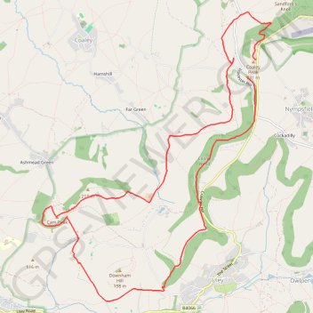
Cam Peak
- Distance: 13.1 Km
- Elevation gain: 400 m
- Maximum elevation: 242 m
- Elevation loss: 387 m
- Minimum elevation: 95 m
- Moving time: 2 h 50 m
- Moving speed: 4.6 Km/h
- Maximum speed: 14.9 Km/h
- Total time: 3 h 26 m
- Global speed: 3.8 Km/h
Interactive trail map
Trail profile
- Distance: 13.1 Km
- Elevation gain: 400 m
- Maximum elevation: 242 m
- Elevation loss: 387 m
- Minimum elevation: 95 m
- Moving time: 2 h 50 m
- Moving speed: 4.6 Km/h
- Maximum speed: 14.9 Km/h
- Total time: 3 h 26 m
- Global speed: 3.8 Km/h
About this trail
Name: Cam Peak trail, distance, elevation, map, profile, GPS track
Coordinates: 51.68055 -2.34004 51.71517 -2.29583
Other hiking, mountain biking, running and outdoor activity trails
Click on a trail to view its statistics, map and profile.
Coaley Peak to Dursley
United Kingdom > England > Gloucestershire > Stroud > Nympsfield > Cockadilly
Distance: 17.5 Km • Elevation gain: 560 m • Maximum elevation: 242 m
Walk through Uley, Cam Peak, and Downham Hill
United Kingdom > England > Gloucestershire > Stroud > Uley
Distance: 10.0 Km • Elevation gain: 409 m • Maximum elevation: 231 m
Coaley to Dursley loop walk
United Kingdom > England > Gloucestershire > Stroud > Nympsfield > Cockadilly
Distance: 16.4 Km • Elevation gain: 553 m • Maximum elevation: 243 m
Crawley, Uley, Cam
United Kingdom > England > Gloucestershire > Stroud > Nympsfield > Cockadilly
Distance: 20.3 Km • Elevation gain: 604 m • Maximum elevation: 248 m
Dean2023-311
United Kingdom > England > Oxfordshire > Oxford
Distance: 310.3 Km • Elevation gain: 3,366 m • Maximum elevation: 290 m