Thank you for supporting this site ❤️
Make a donation
Make a donation
Gear up for your next adventure:
As an Amazon Associate, this site earns from qualifying purchases at no extra cost to you.
Ourimbah Mountain Bike Loop
Interactive trail map
Thank you for supporting this site ❤️
Make a donation
Make a donation
Gear up for your next adventure:
As an Amazon Associate, this site earns from qualifying purchases at no extra cost to you.
Trail profile
- Distance: 10.4 Km
- Elevation gain: 206 m
- Maximum elevation: 87 m
- Elevation loss: 206 m
- Minimum elevation: 25 m
Thank you for supporting this site ❤️
Make a donation
Make a donation
Gear up for your next adventure:
As an Amazon Associate, this site earns from qualifying purchases at no extra cost to you.
About this trail
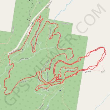
Name: Ourimbah Mountain Bike Loop trail, distance, elevation, map, profile, GPS track
Coordinates: -33.28594 151.37120 -33.27726 151.38458
Topography: New South Wales topographic map, elevation, terrain
Thank you for supporting this site ❤️
Make a donation
Make a donation
Gear up for your next adventure:
🧊Insulated Stainless Steel Flasks - Keep water cold for 24 hours in the heat or coffee hot in the cold
As an Amazon Associate, this site earns from qualifying purchases at no extra cost to you.