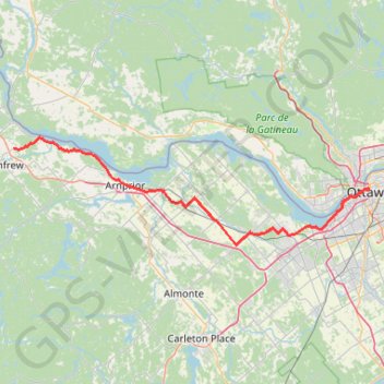
Renfrew - Ottawa
Interactive trail map
Trail profile
- Distance: 98.4 Km
- Elevation gain: 459 m
- Maximum elevation: 168 m
- Elevation loss: 546 m
- Minimum elevation: 44 m
About this trail
Name: Renfrew - Ottawa trail, distance, elevation, map, profile, GPS track
Coordinates: 45.31784 -76.65591 45.52410 -75.68894
Other hiking, mountain biking, running and outdoor activity trails
Click on a trail to view its statistics, map and profile.
Ottawa - Grenville-sur-la-Rouge
Canada > Ontario > (Old) Ottawa
Ottawa River. #Bike #Ottawa #GrenvilleSurLaRouge
Distance: 93.5 Km • Elevation gain: 330 m • Maximum elevation: 73 m
Brockville - Ottawa
Canada > Ontario > Brockville > Brockville
#Bike #Brockville #Ottawa
Distance: 118.4 Km • Elevation gain: 375 m • Maximum elevation: 134 m
Hollow Glen
Canada > Quebec > Les Collines-de-l'Outaouais > Chelsea
Gatineau Park. #Hiking #Snowshoeing #Loop #Gatineau
Distance: 7.8 Km • Elevation gain: 270 m • Maximum elevation: 345 m
Shirleys Bay - Trail 10 Loop Walk
Distance: 5.1 Km • Elevation gain: 25 m • Maximum elevation: 68 m
Boucle de la Forêt Boucher
Distance: 5.0 Km • Elevation gain: 22 m • Maximum elevation: 123 m