Import a GPX file

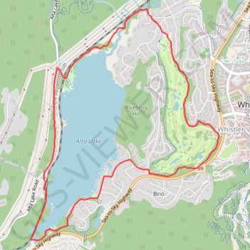
Whistler - Alta Lake

#Hiking #Loop #Whistler #Alta

  • Distance: 8.7 Km
  • Elevation gain: 120 m
  • Maximum elevation: 679 m
  • Elevation loss: 120 m
  • Minimum elevation: 639 m

Interactive trail map

Trail profile

  • Distance: 8.7 Km
  • Elevation gain: 120 m
  • Maximum elevation: 679 m
  • Elevation loss: 120 m
  • Minimum elevation: 639 m

About this trail

Other hiking, mountain biking, running and outdoor activity trails

Click on a trail to view its statistics, map and profile.

Cheakamus River and Lillooet River

Canada > British Columbia > Squamish-Lillooet Regional District > Area D (Elaho/Garibaldi)

Bikepack from Daisy Lake along Cheakamus River and Lillooet River via Alta Lake, Whistler, Green Lake, Shadow Lake, Nairn Falls, One Mile Lake and Pemberton. #Bike #Nature #River #Lake #Mountain #Forest

Distance: 84.6 Km • Elevation gain: 1,233 m • Maximum elevation: 754 m

Vancouver - Golden

Canada > British Columbia > Metro Vancouver Regional District > Vancouver

#Bike #Vancouver #Golden

Distance: 827.6 Km • Elevation gain: 9,376 m • Maximum elevation: 1,347 m

Gear up for your next adventure:

👕UPF 50+ Sun Shirts - Essential protection against the harsh Australian sun during field work
🧊Insulated Stainless Steel Flasks - Keep water cold for 24 hours in the heat or coffee hot in the cold
🎒Hiking Backpacks - Backpacks designed for hiking and trekking
🕶️Polarized Outdoor Sunglasses - Reduce glare from rocks and water for better visual navigation
🏕️Camping Gear - Essential camping equipment

As an Amazon Associate, this site earns from qualifying purchases at no extra cost to you.