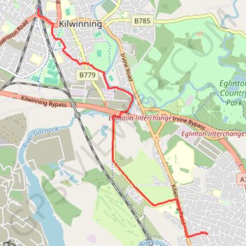
Irvine, Scotland to Kilwinning
Afternoon Bike Ride
- Distance: 5.9 Km
- Elevation gain: 21 m
- Maximum elevation: 22 m
- Elevation loss: 12 m
- Minimum elevation: 5 m
- Moving time: 17 m 55 s
- Moving speed: 19.9 Km/h
- Maximum speed: 27.5 Km/h
- Total time: 17 m 55 s
- Global speed: 19.9 Km/h
Interactive trail map
Trail profile
- Distance: 5.9 Km
- Elevation gain: 21 m
- Maximum elevation: 22 m
- Elevation loss: 12 m
- Minimum elevation: 5 m
- Moving time: 17 m 55 s
- Moving speed: 19.9 Km/h
- Maximum speed: 27.5 Km/h
- Total time: 17 m 55 s
- Global speed: 19.9 Km/h
About this trail
Name: Irvine, Scotland to Kilwinning trail, distance, elevation, map, profile, GPS track
Start: Green Avenue, Irvine, North Ayrshire, Scotland, KA12 0UH, United Kingdom (55.62404 -4.66716)
End: Pennyburn Road, Kilwinning, North Ayrshire, Scotland, KA13 6SS, United Kingdom (55.65598 -4.70953)
Coordinates: 55.62361 -4.70977 55.65598 -4.66716
Other hiking, mountain biking, running and outdoor activity trails
Click on a trail to view its statistics, map and profile.
Irvine, Scotland to Stevenston and back
United Kingdom > Scotland > North Ayrshire > Irvine
Morning Bike Ride
Distance: 18.9 Km • Elevation gain: 69 m • Maximum elevation: 28 m
Irvine, Scotland to Troon and back
United Kingdom > Scotland > North Ayrshire > Irvine
Evening Bike Ride
Distance: 33.8 Km • Elevation gain: 383 m • Maximum elevation: 128 m
Irvine, Scotland to Largs and back
United Kingdom > Scotland > North Ayrshire > Irvine
Morning Bike Ride
Distance: 66.9 Km • Elevation gain: 324 m • Maximum elevation: 35 m
Irvine, Scotland to Eglinton Country Park and back
United Kingdom > Scotland > North Ayrshire > Irvine
Loop Bike
Distance: 13.7 Km • Elevation gain: 67 m • Maximum elevation: 32 m
Shewalton Wood Wildlife Reserve & Barassie Beach
United Kingdom > Scotland > North Ayrshire > Irvine
Bike
Distance: 26.1 Km • Elevation gain: 92 m • Maximum elevation: 18 m
Irvine, Scotland to Troon and back
United Kingdom > Scotland > North Ayrshire > Irvine
Afternoon Loop Bike Ride
Distance: 33.7 Km • Elevation gain: 313 m • Maximum elevation: 129 m
Irvine, Scotland to West Kilbride and back
United Kingdom > Scotland > North Ayrshire > Irvine
Afternoon Bike Ride
Distance: 40.2 Km • Elevation gain: 283 m • Maximum elevation: 101 m
Irvine, Scotland to Greenan Castle and back
United Kingdom > Scotland > North Ayrshire > Irvine
Bike
Distance: 59.4 Km • Elevation gain: 237 m • Maximum elevation: 27 m
Irvine, Scotland to Barassie Beach and back
United Kingdom > Scotland > North Ayrshire > Irvine
Bike
Distance: 21.7 Km • Elevation gain: 86 m • Maximum elevation: 15 m
Irvine, Scotland to Stevenston and back
United Kingdom > Scotland > North Ayrshire > Irvine
Afternoon Bike Ride
Distance: 18.8 Km • Elevation gain: 71 m • Maximum elevation: 28 m
Irvine, Scotland to Stevenston and back
United Kingdom > Scotland > North Ayrshire > Irvine
Evening Bike Ride
Distance: 18.6 Km • Elevation gain: 66 m • Maximum elevation: 22 m
Irvine, Scotland to Stevenston and back
United Kingdom > Scotland > North Ayrshire > Irvine
Morning Bike Ride
Distance: 19.0 Km • Elevation gain: 75 m • Maximum elevation: 29 m
Irvine, Scotland to Saltcoats and back
United Kingdom > Scotland > North Ayrshire > Irvine
Afternoon Bike Ride
Distance: 22.4 Km • Elevation gain: 81 m • Maximum elevation: 22 m
Irvine, Scotland to Stevenston and back
United Kingdom > Scotland > North Ayrshire > Irvine
Bike
Distance: 21.4 Km • Elevation gain: 88 m • Maximum elevation: 28 m
Irvine, Scotland to Stevenston and back
United Kingdom > Scotland > North Ayrshire > Irvine
Bike
Distance: 18.3 Km • Elevation gain: 67 m • Maximum elevation: 22 m
Irvine, Scotland to Stevenston and back
United Kingdom > Scotland > North Ayrshire > Irvine
Bike
Distance: 13.3 Km • Elevation gain: 54 m • Maximum elevation: 27 m
Irvine, Scotland to Stevenston and back
United Kingdom > Scotland > North Ayrshire > Irvine
Bike
Distance: 18.4 Km • Elevation gain: 65 m • Maximum elevation: 28 m
Irvine, Scotland to Stevenston and back
United Kingdom > Scotland > North Ayrshire > Irvine
Bike
Distance: 17.2 Km • Elevation gain: 49 m • Maximum elevation: 13 m
Irvine, Scotland to Ardrossan and back
United Kingdom > Scotland > North Ayrshire > Irvine
Bike
Distance: 31.2 Km • Elevation gain: 115 m • Maximum elevation: 22 m
Irvine, Scotland to Dalry and back
United Kingdom > Scotland > North Ayrshire > Irvine
Evening Loop Bike Ride
Distance: 28.8 Km • Elevation gain: 274 m • Maximum elevation: 106 m
Irvine, Scotland to Dalry and back
United Kingdom > Scotland > North Ayrshire > Irvine
Evening Bike Ride
Distance: 23.3 Km • Elevation gain: 193 m • Maximum elevation: 70 m
Irvine, Scotland to Fairlie and back
United Kingdom > Scotland > North Ayrshire > Irvine
Bike
Distance: 51.8 Km • Elevation gain: 519 m • Maximum elevation: 252 m
Irvine, Scotland to Dalry and back
United Kingdom > Scotland > North Ayrshire > Irvine
Bike
Distance: 26.7 Km • Elevation gain: 254 m • Maximum elevation: 70 m
Irvine, Scotland to Kilwinning
United Kingdom > Scotland > North Ayrshire > Irvine
Afternoon Bike Ride
Distance: 5.3 Km • Elevation gain: 20 m • Maximum elevation: 22 m
Irvine, Scotland to Kilwinning
United Kingdom > Scotland > North Ayrshire > Irvine
Afternoon Bike Ride
Distance: 5.3 Km • Elevation gain: 20 m • Maximum elevation: 22 m
Kilwinning, Scotland to Irvine
United Kingdom > Scotland > North Ayrshire > Kilwinning
Evening Bike Ride
Distance: 7.6 Km • Elevation gain: 22 m • Maximum elevation: 23 m
Irvine, Scotland to Kilwinning
United Kingdom > Scotland > North Ayrshire > Irvine
Morning Bike Ride
Distance: 5.9 Km • Elevation gain: 22 m • Maximum elevation: 22 m
Irvine, Scotland to Ayr and back
United Kingdom > Scotland > North Ayrshire > Irvine
Bike
Distance: 52.9 Km • Elevation gain: 181 m • Maximum elevation: 16 m
Irvine, Scotland to Ayr and back
United Kingdom > Scotland > North Ayrshire > Irvine
Bike
Distance: 46.1 Km • Elevation gain: 135 m • Maximum elevation: 16 m
Eglinton Country Park, Scotland
United Kingdom > Scotland > North Ayrshire > Kilwinning
Afternoon Run
Distance: 2.8 Km • Elevation gain: 16 m • Maximum elevation: 18 m
Sunset at the Beach
United Kingdom > Scotland > North Ayrshire > Irvine
Bike
Distance: 8.2 Km • Elevation gain: 28 m • Maximum elevation: 15 m
Evening Gravel Scouting
United Kingdom > Scotland > North Ayrshire > Irvine
Distance: 22.7 Km • Elevation gain: 81 m • Maximum elevation: 19 m
Irvine, Scotland
United Kingdom > Scotland > North Ayrshire > Irvine
Evening Loop Bike Ride
Distance: 34.3 Km • Elevation gain: 89 m • Maximum elevation: 15 m
Irvine Loop Bike
United Kingdom > Scotland > North Ayrshire > Irvine
Afternoon Ride
Distance: 14.5 Km • Elevation gain: 45 m • Maximum elevation: 16 m
Escort to Troon
United Kingdom > Scotland > North Ayrshire > Irvine
Bike
Distance: 34.9 Km • Elevation gain: 125 m • Maximum elevation: 19 m
Irvine Beach
United Kingdom > Scotland > North Ayrshire > Irvine
Bike
Distance: 8.5 Km • Elevation gain: 33 m • Maximum elevation: 16 m
Beach Gravel
United Kingdom > Scotland > North Ayrshire > Irvine
Distance: 12.2 Km • Elevation gain: 56 m • Maximum elevation: 16 m