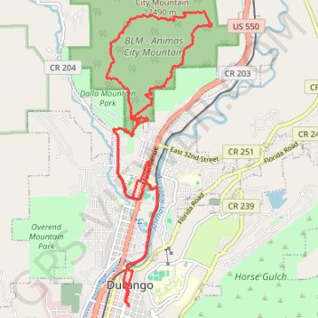
The new Upper Merve - Animas City Mountain
- Distance: 21.3 Km
- Elevation gain: 551 m
- Maximum elevation: 2,462 m
- Elevation loss: 551 m
- Minimum elevation: 1,988 m
- Moving time: 1 h 56 m
- Moving speed: 11.0 Km/h
- Maximum speed: 39.7 Km/h
- Total time: 3 h 39 m
- Global speed: 5.8 Km/h
Interactive trail map
Trail profile
- Distance: 21.3 Km
- Elevation gain: 551 m
- Maximum elevation: 2,462 m
- Elevation loss: 551 m
- Minimum elevation: 1,988 m
- Moving time: 1 h 56 m
- Moving speed: 11.0 Km/h
- Maximum speed: 39.7 Km/h
- Total time: 3 h 39 m
- Global speed: 5.8 Km/h
About this trail
Name: The new Upper Merve - Animas City Mountain trail, distance, elevation, map, profile, GPS track
Start: 947, East 4th Avenue, Durango, La Plata County, Colorado, 81302, United States (37.27331 -107.87688)
End: 947, East 4th Avenue, Durango, La Plata County, Colorado, 81302, United States (37.27330 -107.87689)
Coordinates: 37.27330 -107.88167 37.32284 -107.85920
Other hiking, mountain biking, running and outdoor activity trails
Click on a trail to view its statistics, map and profile.
Mesa Connector, Telegraph Connector, Mike's Trail, Cuchillo Trail and Cap's Trail
United States > Colorado > La Plata County > Durango
Distance: 16.9 Km • Elevation gain: 409 m • Maximum elevation: 2,276 m
First time riding Medicine 🤘 thought it would be harder? 🤷♂️
United States > Colorado > La Plata County > Durango
Distance: 14.0 Km • Elevation gain: 446 m • Maximum elevation: 2,208 m
Animas River, Animas Mountain, Lupine and Swerve loop trails
United States > Colorado > La Plata County > Durango
Distance: 17.1 Km • Elevation gain: 502 m • Maximum elevation: 2,394 m
Overend Mountain Park loop trails
United States > Colorado > La Plata County > Durango
Distance: 11.2 Km • Elevation gain: 290 m • Maximum elevation: 2,151 m
Dog park and business park
United States > Colorado > La Plata County > Durango
Distance: 29.9 Km • Elevation gain: 329 m • Maximum elevation: 2,027 m
Animas Mountain
United States > Colorado > La Plata County > Durango
Distance: 20.1 Km • Elevation gain: 658 m • Maximum elevation: 2,457 m