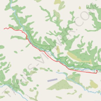
Import a GPX file

Waihi Gorge Walk

  • Distance: 11.4 Km
  • Elevation gain: 287 m
  • Maximum elevation: 509 m
  • Elevation loss: 286 m
  • Minimum elevation: 299 m

Interactive trail map

Trail profile

  • Distance: 11.4 Km
  • Elevation gain: 287 m
  • Maximum elevation: 509 m
  • Elevation loss: 286 m
  • Minimum elevation: 299 m

About this trail

Name: Waihi Gorge Walk trail, distance, elevation, map, profile, GPS track

Start: Timaru District, New Zealand (-44.00225 171.15557)

End: Timaru District, New Zealand (-44.00259 171.15545)

Coordinates: -44.00381 171.10014 -43.98404 171.15606

Other hiking, mountain biking, running and outdoor activity trails

Click on a trail to view its statistics, map and profile.

Tour Te Waipounamu

New Zealand > Tasman > Tasman District > Port Pūponga

Bikepacking race through the South Island of New Zealand. #Bike #Race #Island #Sea #Pacific #Ocean #Nature #Mountain #Forest #Countryside

Distance: 1,321.0 Km • Elevation gain: 23,362 m • Maximum elevation: 1,946 m

Gear up for your next adventure:

🧊Insulated Stainless Steel Flasks - Keep water cold for 24 hours in the heat or coffee hot in the cold
🎒Tactical Waist Packs - Quick access to your compass, phone, and snacks while walking
🏕️Camping Gear - Essential camping equipment
👄SPF Lip Balm - Prevent sun and wind-burnt lips on mountain ridges
🦘Outback Survival Gear - Essential gear for Australian outback

As an Amazon Associate, this site earns from qualifying purchases at no extra cost to you.