Import a GPX file

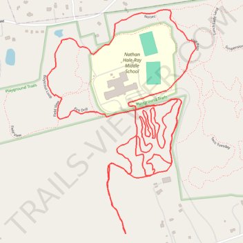
Playground Trails MTB

  • Distance: 6.8 Km
  • Elevation gain: 122 m
  • Maximum elevation: 131 m
  • Elevation loss: 122 m
  • Minimum elevation: 93 m
  • Moving time: 42 m 16 s
  • Moving speed: 9.6 Km/h
  • Maximum speed: 23.4 Km/h
  • Total time: 43 m 45 s
  • Global speed: 9.3 Km/h

Interactive trail map

Trail profile

  • Distance: 6.8 Km
  • Elevation gain: 122 m
  • Maximum elevation: 131 m
  • Elevation loss: 122 m
  • Minimum elevation: 93 m
  • Moving time: 42 m 16 s
  • Moving speed: 9.6 Km/h
  • Maximum speed: 23.4 Km/h
  • Total time: 43 m 45 s
  • Global speed: 9.3 Km/h
👉 Easily get elevation data in JSON, GeoTIFF and KML formats using Elevation API
Thank you for supporting this site ❤️
Make a donation

Gear up for your next adventure:

As an Amazon Associate, this site earns from qualifying purchases at no extra cost to you.

About this trail

Gear up for your next adventure:

💡Collapsible Camping Lanterns - Illuminate your base camp or tent for map studying at night
🦯Adjustable Trekking Poles - Reduce impact on knees when descending steep topographic ridges
🧊Insulated Stainless Steel Flasks - Keep water cold for 24 hours in the heat or coffee hot in the cold
🥾Trail Running Shoes - Shoes for trail running
👣Snake & Scrub Gaiters - Protection against spinifex, mud, and snakes while walking off-track

As an Amazon Associate, this site earns from qualifying purchases at no extra cost to you.