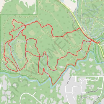
Margaret River Loop
Interactive trail map
Trail profile
- Distance: 18.3 Km
- Elevation gain: 276 m
- Maximum elevation: 111 m
- Elevation loss: 276 m
- Minimum elevation: 61 m
About this trail
Name: Margaret River Loop trail, distance, elevation, map, profile, GPS track
Coordinates: -33.94280 115.04404 -33.92888 115.06867
Topography: Western Australia topographic map, elevation, terrain
Other hiking, mountain biking, running and outdoor activity trails
Click on a trail to view its statistics, map and profile.
Pines MTB Trails
Distance: 19.5 Km • Elevation gain: 341 m • Maximum elevation: 118 m
Pines trails at Carter road MTB trails Margaret River
Bramley Mountain Biking
Distance: 15.7 Km • Elevation gain: 280 m • Maximum elevation: 118 m
Wooditijup National Park - Bramley Mountain Biking
Australia > Western Australia > Margaret River
Distance: 35.3 Km • Elevation gain: 516 m • Maximum elevation: 122 m