Slot in the Chawar
חריץ בחוואר: מסלול חווארים פראי בערבות סדום
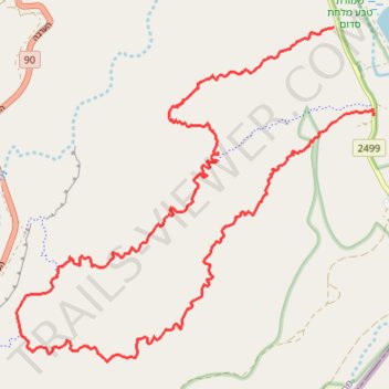
- Distance: 23.3 Km
- Elevation gain: 446 m
- Maximum elevation: -207 m
- Elevation loss: 453 m
- Minimum elevation: -364 m
- Moving time: 6 h 5 m
- Moving speed: 3.8 Km/h
- Maximum speed: 4.2 Km/h
- Total time: 6 h 5 m
- Global speed: 3.8 Km/h
Interactive trail map
Trail profile
- Distance: 23.3 Km
- Elevation gain: 446 m
- Maximum elevation: -207 m
- Elevation loss: 453 m
- Minimum elevation: -364 m
- Moving time: 6 h 5 m
- Moving speed: 3.8 Km/h
- Maximum speed: 4.2 Km/h
- Total time: 6 h 5 m
- Global speed: 3.8 Km/h
About this trail
Name: Slot in the Chawar trail, distance, elevation, map, profile, GPS track
Start: 2499, Tamar Regional Council, Beersheba Subdistrict, South District, Israel (30.96918 35.35676)
End: 2499, Tamar Regional Council, Beersheba Subdistrict, South District, Israel (30.95598 35.36366)
Coordinates: 30.91956 35.30145 30.96918 35.36366