Stoney Creek Loop
Stoney Creek Conservation Area. #Hiking #MTB #Running #Snowshoeing #Loop #StoneyCreek
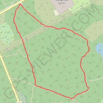
- Distance: 3.9 Km
- Elevation gain: 19 m
- Maximum elevation: 116 m
- Elevation loss: 19 m
- Minimum elevation: 102 m
Interactive trail map
Trail profile
- Distance: 3.9 Km
- Elevation gain: 19 m
- Maximum elevation: 116 m
- Elevation loss: 19 m
- Minimum elevation: 102 m
About this trail
Name: Stoney Creek Loop trail, distance, elevation, map, profile, GPS track
Coordinates: 45.29503 -75.81804 45.30656 -75.80511
Other hiking, mountain biking, running and outdoor activity trails
Click on a trail to view its statistics, map and profile.
Brockville - Ottawa
Canada > Ontario > Brockville > Brockville
#Bike #Brockville #Ottawa
Distance: 118.4 Km • Elevation gain: 375 m • Maximum elevation: 134 m