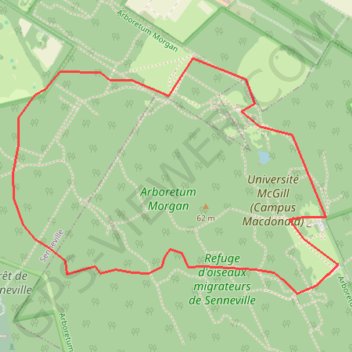
Arboretum Morgan Yellow Trail
#Hiking #Snowshoeing #Ski
- Distance: 4.6 Km
- Elevation gain: 33 m
- Maximum elevation: 56 m
- Elevation loss: 33 m
- Minimum elevation: 33 m
Interactive trail map
Trail profile
- Distance: 4.6 Km
- Elevation gain: 33 m
- Maximum elevation: 56 m
- Elevation loss: 33 m
- Minimum elevation: 33 m
About this trail
Name: Arboretum Morgan Yellow Trail trail, distance, elevation, map, profile, GPS track
Coordinates: 45.42821 -73.95953 45.43728 -73.94168
Other hiking, mountain biking, running and outdoor activity trails
Click on a trail to view its statistics, map and profile.
East Hawkesbury - Montréal
Canada > Ontario > Prescott and Russell Counties > East Hawkesbury
#Bike #EastHawkesbury #Montréal
Distance: 91.4 Km • Elevation gain: 393 m • Maximum elevation: 91 m
Salaberry-de-Valleyfield - Montréal
Canada > Quebec > Beauharnois-Salaberry > Salaberry-de-Valleyfield
#Bike
Distance: 89.9 Km • Elevation gain: 363 m • Maximum elevation: 70 m