Thank you for supporting this site ❤️
Make a donation
Make a donation
Gear up for your next adventure:
As an Amazon Associate, this site earns from qualifying purchases at no extra cost to you.
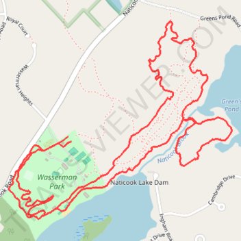
Wasserman Park
- Distance: 6.8 Km
- Elevation gain: 97 m
- Maximum elevation: 108 m
- Elevation loss: 100 m
- Minimum elevation: 57 m
- Moving time: 55 m 28 s
- Moving speed: 7.3 Km/h
- Maximum speed: 12.9 Km/h
- Total time: 55 m 28 s
- Global speed: 7.3 Km/h
Interactive trail map
Thank you for supporting this site ❤️
Make a donation
Make a donation
Gear up for your next adventure:
As an Amazon Associate, this site earns from qualifying purchases at no extra cost to you.
Trail profile
- Distance: 6.8 Km
- Elevation gain: 97 m
- Maximum elevation: 108 m
- Elevation loss: 100 m
- Minimum elevation: 57 m
- Moving time: 55 m 28 s
- Moving speed: 7.3 Km/h
- Maximum speed: 12.9 Km/h
- Total time: 55 m 28 s
- Global speed: 7.3 Km/h
Thank you for supporting this site ❤️
Make a donation
Make a donation
Gear up for your next adventure:
As an Amazon Associate, this site earns from qualifying purchases at no extra cost to you.
About this trail
Name: Wasserman Park trail, distance, elevation, map, profile, GPS track
Coordinates: 42.81964 -71.53376 42.82936 -71.51879
Thank you for supporting this site ❤️
Make a donation
Make a donation
Gear up for your next adventure:
As an Amazon Associate, this site earns from qualifying purchases at no extra cost to you.