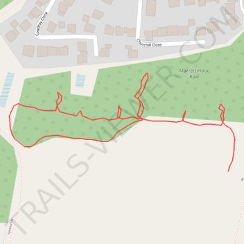
Edge of field and woods
- Distance: 0.8 Km
- Elevation gain: 9 m
- Maximum elevation: 53 m
- Elevation loss: 7 m
- Minimum elevation: 46 m
- Moving time: 11 m 45 s
- Moving speed: 3.8 Km/h
- Maximum speed: 7.5 Km/h
- Total time: 14 m 3 s
- Global speed: 3.2 Km/h
Interactive trail map
Trail profile
- Distance: 0.8 Km
- Elevation gain: 9 m
- Maximum elevation: 53 m
- Elevation loss: 7 m
- Minimum elevation: 46 m
- Moving time: 11 m 45 s
- Moving speed: 3.8 Km/h
- Maximum speed: 7.5 Km/h
- Total time: 14 m 3 s
- Global speed: 3.2 Km/h
About this trail
Name: Edge of field and woods trail, distance, elevation, map, profile, GPS track
Start: Newlands, Winchester, Hampshire, England, PO7 5RT, United Kingdom (50.86944 -1.04824)
Coordinates: 50.86944 -1.05163 50.87040 -1.04814