Thank you for supporting this site ❤️
Make a donation
Make a donation
Gear up for your next adventure:
As an Amazon Associate, this site earns from qualifying purchases at no extra cost to you.
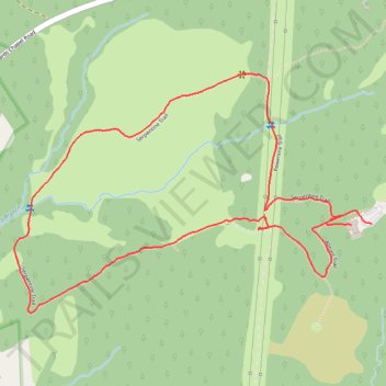
Serpentine Loop Trail
- Distance: 3.7 Km
- Elevation gain: 84 m
- Maximum elevation: 213 m
- Elevation loss: 85 m
- Minimum elevation: 155 m
- Moving time: 1 h 10 m
- Moving speed: 3.1 Km/h
- Maximum speed: 5.4 Km/h
- Total time: 1 h 13 m
- Global speed: 3.0 Km/h
Interactive trail map
Thank you for supporting this site ❤️
Make a donation
Make a donation
Gear up for your next adventure:
As an Amazon Associate, this site earns from qualifying purchases at no extra cost to you.
Trail profile
- Distance: 3.7 Km
- Elevation gain: 84 m
- Maximum elevation: 213 m
- Elevation loss: 85 m
- Minimum elevation: 155 m
- Moving time: 1 h 10 m
- Moving speed: 3.1 Km/h
- Maximum speed: 5.4 Km/h
- Total time: 1 h 13 m
- Global speed: 3.0 Km/h
Thank you for supporting this site ❤️
Make a donation
Make a donation
Gear up for your next adventure:
As an Amazon Associate, this site earns from qualifying purchases at no extra cost to you.
About this trail
Name: Serpentine Loop Trail trail, distance, elevation, map, profile, GPS track
Start: Serpentine Trail, Baltimore County, Maryland, United States (39.41019 -76.83829)
Coordinates: 39.40775 -76.85094 39.41431 -76.83829
Thank you for supporting this site ❤️
Make a donation
Make a donation
Gear up for your next adventure:
As an Amazon Associate, this site earns from qualifying purchases at no extra cost to you.