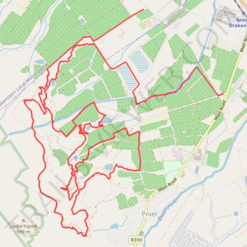
Boschendal MTB Black Route
- Distance: 23.0 Km
- Elevation gain: 759 m
- Maximum elevation: 510 m
- Elevation loss: 767 m
- Minimum elevation: 195 m
Interactive trail map
Trail profile
- Distance: 23.0 Km
- Elevation gain: 759 m
- Maximum elevation: 510 m
- Elevation loss: 767 m
- Minimum elevation: 195 m
About this trail
Name: Boschendal MTB Black Route trail, distance, elevation, map, profile, GPS track
Coordinates: -33.89720 18.93692 -33.86320 18.97281
Other hiking, mountain biking, running and outdoor activity trails
Click on a trail to view its statistics, map and profile.
Boschendal Ride
South Africa > Western Cape > Cape Winelands District Municipality > Drakenstein Local Municipality > Simondium
Distance: 17.1 Km • Elevation gain: 467 m • Maximum elevation: 399 m