Make a donation
Gear up for your next adventure:
As an Amazon Associate, this site earns from qualifying purchases at no extra cost to you.
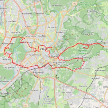
Vilniaus TV bokštas to Vilnius 11301
- Distance: 50.3 Km
- Elevation gain: 756 m
- Maximum elevation: 217 m
- Elevation loss: 765 m
- Minimum elevation: 86 m
Interactive trail map
Make a donation
Gear up for your next adventure:
As an Amazon Associate, this site earns from qualifying purchases at no extra cost to you.
Trail profile
- Distance: 50.3 Km
- Elevation gain: 756 m
- Maximum elevation: 217 m
- Elevation loss: 765 m
- Minimum elevation: 86 m
Make a donation
Gear up for your next adventure:
As an Amazon Associate, this site earns from qualifying purchases at no extra cost to you.
About this trail
Name: Vilniaus TV bokštas to Vilnius 11301 trail, distance, elevation, map, profile, GPS track
Coordinates: 54.66253 25.20670 54.70057 25.39741
Make a donation
Gear up for your next adventure:
As an Amazon Associate, this site earns from qualifying purchases at no extra cost to you.
Other hiking, mountain biking, running and outdoor activity trails
Click on a trail to view its statistics, map and profile.
Vilnius 11301 to 54.688170
Lithuania > Vilnius County > Vilnius
Distance: 21.3 Km • Elevation gain: 340 m • Maximum elevation: 194 m
VIKING_TR001
Lithuania > Vilnius County > Vilnius
Distance: 107.9 Km • Elevation gain: 2,043 m • Maximum elevation: 217 m