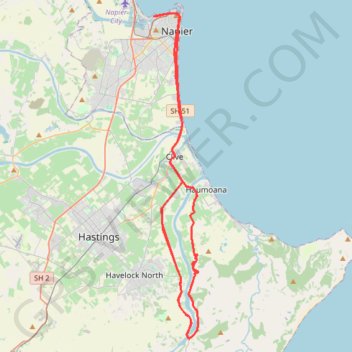
Import a GPX file

Harbour - Hills

#Bike #Loop

  • Distance: 94.1 Km
  • Elevation gain: 747 m
  • Maximum elevation: 87 m
  • Elevation loss: 748 m
  • Minimum elevation: 1 m

Interactive trail map

Trail profile

  • Distance: 94.1 Km
  • Elevation gain: 747 m
  • Maximum elevation: 87 m
  • Elevation loss: 748 m
  • Minimum elevation: 1 m

About this trail

Name: Harbour - Hills trail, distance, elevation, map, profile, GPS track

Start: 46, Nelson Quay, Ahuriri, Napier, Hawke's Bay, 4110, New Zealand (-39.47963 176.89628)

End: 43, Nelson Quay, Ahuriri, Napier, Hawke's Bay, 4110, New Zealand (-39.47960 176.89614)

Coordinates: -39.71740 176.89614 -39.47755 176.93885

Gear up for your next adventure:

📕Hiking Guide Books - Guides for hiking trails
📍Handheld GPS - GPS devices for hiking and navigation
🎒3L Hydration Reservoirs - Hands-free drinking to stay hydrated on steep contour climbs
🪑Portable Backpacking Chairs - A comfortable seat for studying maps at the end of the day
🧭Global Orienteering Compass - High-precision liquid-filled compasses for accurate map reading and navigation

As an Amazon Associate, this site earns from qualifying purchases at no extra cost to you.