Les Échelles - Rochehaut (the Ardennes) - Route 43
An extremely nice short hike, probably the nicest in Belgium.
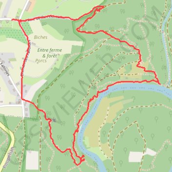
Start your hike at the Church of Rochehaut — or at the beginning of the Route 43 — and follow the sign with a red rectangle on white board. Route 43 is very well marked till the end.
While some slopes are steep, it’s perfectly suitable for almost everyone. It’s unbelievable that authorities discourage doing this easy route, calling it “not for the faint-hearted”. The “ladders” are fun, the route is magnificently marked, well-kept. Just do it!
Important: use hiking shoes, and a pair of mountain sticks is advisable.
Do the route clockwise, so you can enjoy the view on the descent. Otherwise you’ll gonna miss it.
The route is definitely suitable for the kids of 10 and older.
- Distance: 4.2 Km
- Elevation gain: 249 m
- Maximum elevation: 384 m
- Elevation loss: 247 m
- Minimum elevation: 207 m
- Moving time: 1 h 33 m
- Moving speed: 2.7 Km/h
- Maximum speed: 25.3 Km/h
- Total time: 2 h 17 m
- Global speed: 1.8 Km/h
Interactive trail map
Trail profile
- Distance: 4.2 Km
- Elevation gain: 249 m
- Maximum elevation: 384 m
- Elevation loss: 247 m
- Minimum elevation: 207 m
- Moving time: 1 h 33 m
- Moving speed: 2.7 Km/h
- Maximum speed: 25.3 Km/h
- Total time: 2 h 17 m
- Global speed: 1.8 Km/h
About this trail
Name: Les Échelles - Rochehaut (the Ardennes) - Route 43 trail, distance, elevation, map, profile, GPS track
Coordinates: 49.83031 5.01159 49.83949 5.02489
Other hiking, mountain biking, running and outdoor activity trails
Click on a trail to view its statistics, map and profile.
Eurovelo 15 - Strasbourg Rotterdam
France > Grand Est > Bas-Rhin > Strasbourg
Distance: 891.7 Km • Elevation gain: 2,104 m • Maximum elevation: 146 m