Thank you for supporting this site ❤️
Make a donation
Make a donation
Gear up for your next adventure:
As an Amazon Associate, this site earns from qualifying purchases at no extra cost to you.
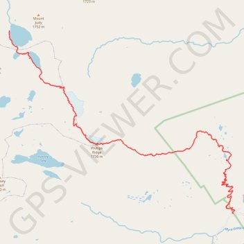
Golden Hinde : Westmin trailhead - Schjelderup Lake
Strathcona Provincial Park. #Hiking #GH #Schjelderup #Strathcona
- Distance: 20.7 Km
- Elevation gain: 1,785 m
- Maximum elevation: 1,720 m
- Elevation loss: 887 m
- Minimum elevation: 387 m
Interactive trail map
Thank you for supporting this site ❤️
Make a donation
Make a donation
Gear up for your next adventure:
📣High-Decibel Survival Whistles - Signaling tool for rescue that carries much further than a human voice
As an Amazon Associate, this site earns from qualifying purchases at no extra cost to you.
Trail profile
- Distance: 20.7 Km
- Elevation gain: 1,785 m
- Maximum elevation: 1,720 m
- Elevation loss: 887 m
- Minimum elevation: 387 m
Thank you for supporting this site ❤️
Make a donation
Make a donation
Gear up for your next adventure:
As an Amazon Associate, this site earns from qualifying purchases at no extra cost to you.
About this trail
Name: Golden Hinde : Westmin trailhead - Schjelderup Lake trail, distance, elevation, map, profile, GPS track
Coordinates: 49.57492 -125.72376 49.63331 -125.61259
Thank you for supporting this site ❤️
Make a donation
Make a donation
Gear up for your next adventure:
As an Amazon Associate, this site earns from qualifying purchases at no extra cost to you.