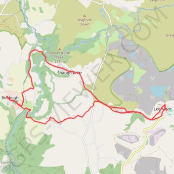
Bickleigh - Lee Moor
- Distance: 16.5 Km
- Elevation gain: 368 m
- Maximum elevation: 231 m
- Elevation loss: 369 m
- Minimum elevation: 33 m
- Moving time: 4 h 1 m
- Moving speed: 4.1 Km/h
- Maximum speed: 13.7 Km/h
- Total time: 4 h 11 m
- Global speed: 3.9 Km/h
Interactive trail map
Trail profile
- Distance: 16.5 Km
- Elevation gain: 368 m
- Maximum elevation: 231 m
- Elevation loss: 369 m
- Minimum elevation: 33 m
- Moving time: 4 h 1 m
- Moving speed: 4.1 Km/h
- Maximum speed: 13.7 Km/h
- Total time: 4 h 11 m
- Global speed: 3.9 Km/h
About this trail
Name: Bickleigh - Lee Moor trail, distance, elevation, map, profile, GPS track
Start: Woolwell, Bickleigh, South Hams, Devon, England, PL6 7AF, United Kingdom (50.44237 -4.08598)
End: Woolwell, Bickleigh, South Hams, Devon, England, PL6 7AF, United Kingdom (50.44218 -4.08598)
Coordinates: 50.43413 -4.08598 50.45625 -4.01034