Nub Peak via Sunburst Lake and The Nub
- Distance: 4.7 Km
- Elevation gain: 561 m
- Maximum elevation: 2,727 m
- Elevation loss: 23 m
- Minimum elevation: 2,188 m
Interactive trail map
Trail profile
- Distance: 4.7 Km
- Elevation gain: 561 m
- Maximum elevation: 2,727 m
- Elevation loss: 23 m
- Minimum elevation: 2,188 m
About this trail
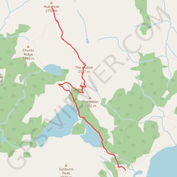
Name: Nub Peak via Sunburst Lake and The Nub trail, distance, elevation, map, profile, GPS track
Coordinates: 50.90417 -115.65779 50.93004 -115.63939
Other hiking, mountain biking, running and outdoor activity trails
Click on a trail to view its statistics, map and profile.
Assiniboine Lodge - The Nublet - Nub Peak - Elizabeth lake - Sunburst Valley - Cerulean Lake
Canada > British Columbia > Regional District of East Kootenay > Area G (Forster Creek/Mount Assiniboine)
Mount Assiniboine Provincial Park. #Hiking #Loop #Assiniboine
Distance: 12.5 Km • Elevation gain: 735 m • Maximum elevation: 2,738 m