Thank you for supporting this site ❤️
Make a donation
Make a donation
Gear up for your next adventure:
As an Amazon Associate, this site earns from qualifying purchases at no extra cost to you.
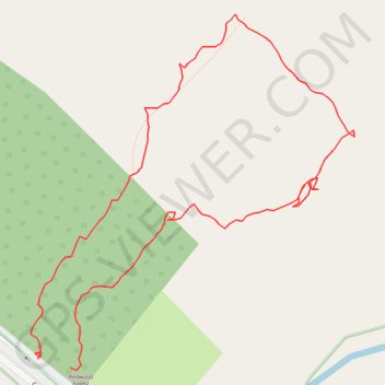
Redwood Forest
- Distance: 1.1 Km
- Elevation gain: 26 m
- Maximum elevation: 218 m
- Elevation loss: 27 m
- Minimum elevation: 197 m
- Moving time: 26 m 15 s
- Moving speed: 2.5 Km/h
- Maximum speed: 5.1 Km/h
- Total time: 53 m
- Global speed: 1.2 Km/h
Interactive trail map
Thank you for supporting this site ❤️
Make a donation
Make a donation
Gear up for your next adventure:
As an Amazon Associate, this site earns from qualifying purchases at no extra cost to you.
Trail profile
- Distance: 1.1 Km
- Elevation gain: 26 m
- Maximum elevation: 218 m
- Elevation loss: 27 m
- Minimum elevation: 197 m
- Moving time: 26 m 15 s
- Moving speed: 2.5 Km/h
- Maximum speed: 5.1 Km/h
- Total time: 53 m
- Global speed: 1.2 Km/h
Thank you for supporting this site ❤️
Make a donation
Make a donation
Gear up for your next adventure:
As an Amazon Associate, this site earns from qualifying purchases at no extra cost to you.
About this trail
Name: Redwood Forest trail, distance, elevation, map, profile, GPS track
Coordinates: -37.71965 145.75216 -37.71691 145.75531
Topography: Melbourne topographic map, elevation, terrain
Thank you for supporting this site ❤️
Make a donation
Make a donation
Gear up for your next adventure:
As an Amazon Associate, this site earns from qualifying purchases at no extra cost to you.
Other hiking, mountain biking, running and outdoor activity trails
Click on a trail to view its statistics, map and profile.
Tallarook - Eildon - Hurstbridge
Australia > Victoria > Tallarook
#Bike
Distance: 278.8 Km • Elevation gain: 4,897 m • Maximum elevation: 868 m