Colle Croce di Ferro
A nice walk on the Alps!!
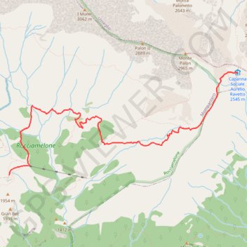
- Distance: 7.1 Km
- Elevation gain: 725 m
- Maximum elevation: 2,535 m
- Elevation loss: 159 m
- Minimum elevation: 1,942 m
- Moving time: 2 h 26 m
- Moving speed: 2.9 Km/h
- Maximum speed: 30.9 Km/h
- Total time: 3 h 5 m
- Global speed: 2.3 Km/h
Interactive trail map
Trail profile
- Distance: 7.1 Km
- Elevation gain: 725 m
- Maximum elevation: 2,535 m
- Elevation loss: 159 m
- Minimum elevation: 1,942 m
- Moving time: 2 h 26 m
- Moving speed: 2.9 Km/h
- Maximum speed: 30.9 Km/h
- Total time: 3 h 5 m
- Global speed: 2.3 Km/h
About this trail
Name: Colle Croce di Ferro trail, distance, elevation, map, profile, GPS track
Coordinates: 45.17228 7.08558 45.18692 7.13169
Other hiking, mountain biking, running and outdoor activity trails
Click on a trail to view its statistics, map and profile.
PT23DS2 Lörrach → Cadaqués
Germany > Baden-Württemberg > Landkreis Lörrach > Lörrach (Kernstadt)
Distance: 1,050.7 Km • Elevation gain: 13,130 m • Maximum elevation: 1,505 m