Make a donation
Gear up for your next adventure:
As an Amazon Associate, this site earns from qualifying purchases at no extra cost to you.
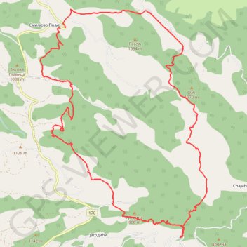
Povlen/Zarožje-Roge-kanjon Rogačice-Oab
- Distance: 17.3 Km
- Elevation gain: 909 m
- Maximum elevation: 1,051 m
- Elevation loss: 918 m
- Minimum elevation: 582 m
- Moving time: 6 h 26 m
- Moving speed: 2.7 Km/h
- Maximum speed: 10.4 Km/h
- Total time: 9 h 33 m
- Global speed: 1.8 Km/h
Interactive trail map
Make a donation
Gear up for your next adventure:
As an Amazon Associate, this site earns from qualifying purchases at no extra cost to you.
Trail profile
- Distance: 17.3 Km
- Elevation gain: 909 m
- Maximum elevation: 1,051 m
- Elevation loss: 918 m
- Minimum elevation: 582 m
- Moving time: 6 h 26 m
- Moving speed: 2.7 Km/h
- Maximum speed: 10.4 Km/h
- Total time: 9 h 33 m
- Global speed: 1.8 Km/h
Make a donation
Gear up for your next adventure:
As an Amazon Associate, this site earns from qualifying purchases at no extra cost to you.
About this trail
Name: Povlen/Zarožje-Roge-kanjon Rogačice-Oab trail, distance, elevation, map, profile, GPS track
Coordinates: 44.09585 19.66286 44.13063 19.69823
Make a donation
Gear up for your next adventure:
As an Amazon Associate, this site earns from qualifying purchases at no extra cost to you.
Other hiking, mountain biking, running and outdoor activity trails
Click on a trail to view its statistics, map and profile.
2022_Yu
Slovenia > Ajdovščina > Žapuže
Distance: 2,457.3 Km • Elevation gain: 32,048 m • Maximum elevation: 1,950 m
Povlen: OAB 1070m, kanjon Rogačice, Zarožje
Serbia > Central Serbia > Zlatibor Administrative District > Bajina Basta Municipality > Zarozje > Смиљево Поље
Distance: 14.2 Km • Elevation gain: 803 m • Maximum elevation: 1,073 m