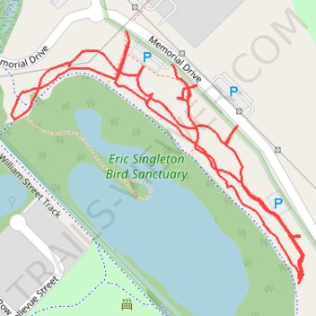
Eric Singleton Bird Sanctuary
- Distance: 1.8 Km
- Elevation gain: 10 m
- Maximum elevation: 9 m
- Elevation loss: 11 m
- Minimum elevation: 4 m
- Moving time: 22 m 38 s
- Moving speed: 4.8 Km/h
- Maximum speed: 6.8 Km/h
- Total time: 23 m 47 s
- Global speed: 4.5 Km/h
Interactive trail map
Trail profile
- Distance: 1.8 Km
- Elevation gain: 10 m
- Maximum elevation: 9 m
- Elevation loss: 11 m
- Minimum elevation: 4 m
- Moving time: 22 m 38 s
- Moving speed: 4.8 Km/h
- Maximum speed: 6.8 Km/h
- Total time: 23 m 47 s
- Global speed: 4.5 Km/h
About this trail
Name: Eric Singleton Bird Sanctuary trail, distance, elevation, map, profile, GPS track
Start: Memorial Drive, Bayswater, Perth, Western Australia, 6053, Australia (-31.92787 115.92504)
End: Memorial Drive, Bayswater, Perth, Western Australia, 6053, Australia (-31.92601 115.92354)
Coordinates: -31.92839 115.92150 -31.92566 115.92523
Topography: Perth topographic map, elevation, terrain
Other hiking, mountain biking, running and outdoor activity trails
Click on a trail to view its statistics, map and profile.
2021 Toodyay return via Kep
Distance: 229.9 Km • Elevation gain: 1,859 m • Maximum elevation: 357 m