Import a GPX file

Bords d'Oise de la ville d'art et d'histoire à l'axe majeur - Cergy-Pontoise

  • Distance: 13.1 Km
  • Elevation gain: 146 m
  • Maximum elevation: 108 m
  • Elevation loss: 75 m
  • Minimum elevation: 22 m

Interactive trail map

Trail profile

  • Distance: 13.1 Km
  • Elevation gain: 146 m
  • Maximum elevation: 108 m
  • Elevation loss: 75 m
  • Minimum elevation: 22 m

About this trail
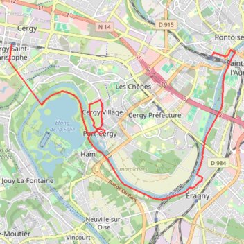
Name: Bords d'Oise de la ville d'art et d'histoire à l'axe majeur - Cergy-Pontoise trail, distance, elevation, map, profile, GPS track

Start: Place du Général de Gaulle, Centre-Ville, Pontoise, Val-d'Oise, Ile-de-France, Metropolitan France, 95300, France (49.04724 2.09549)

End: Cergy Saint-Christophe, Horloge, Cergy, Pontoise, Val-d'Oise, Ile-de-France, Metropolitan France, 95800, France (49.04938 2.03422)

Coordinates: 49.01830 2.03348 49.04938 2.10261

Gear up for your next adventure:

🕶️Polarized Outdoor Sunglasses - Reduce glare from rocks and water for better visual navigation
📱Tablet Tripod Mounts - Steady platforms for viewing digital maps or taking long exposures
📟Satellite Messengers - Two-way satellite communication to stay in touch beyond the cellular grid
🧊Insulated Stainless Steel Flasks - Keep water cold for 24 hours in the heat or coffee hot in the cold
🚴Cycling Backpacks - Backpacks for cyclists

As an Amazon Associate, this site earns from qualifying purchases at no extra cost to you.