Make a donation
Gear up for your next adventure:
As an Amazon Associate, this site earns from qualifying purchases at no extra cost to you.
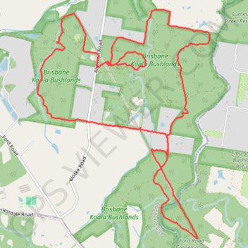
Brisbane Koala Bushlands Loop
Loop hike / run through Brisbane Koala Bushlands. #Hiking #Running #Loop #Forest #Nature #Lake #River
- Distance: 16.2 Km
- Elevation gain: 230 m
- Maximum elevation: 68 m
- Elevation loss: 230 m
- Minimum elevation: 22 m
- Moving time: 2 h 8 m
- Moving speed: 7.5 Km/h
- Maximum speed: 14.3 Km/h
- Total time: 2 h 9 m
- Global speed: 7.5 Km/h
Interactive trail map
Make a donation
Gear up for your next adventure:
As an Amazon Associate, this site earns from qualifying purchases at no extra cost to you.
Trail profile
- Distance: 16.2 Km
- Elevation gain: 230 m
- Maximum elevation: 68 m
- Elevation loss: 230 m
- Minimum elevation: 22 m
- Moving time: 2 h 8 m
- Moving speed: 7.5 Km/h
- Maximum speed: 14.3 Km/h
- Total time: 2 h 9 m
- Global speed: 7.5 Km/h
Make a donation
Gear up for your next adventure:
As an Amazon Associate, this site earns from qualifying purchases at no extra cost to you.
About this trail
Name: Brisbane Koala Bushlands Loop trail, distance, elevation, map, profile, GPS track
Start: Horse Trail, Burbank, Greater Brisbane, Queensland, 4156, Australia (-27.57053 153.16389)
End: Horse Trail, Burbank, Greater Brisbane, Queensland, 4156, Australia (-27.57049 153.16394)
Coordinates: -27.59458 153.15282 -27.56309 153.17955
Topography: Queensland topographic map, elevation, terrain
Make a donation
Gear up for your next adventure:
As an Amazon Associate, this site earns from qualifying purchases at no extra cost to you.
Other hiking, mountain biking, running and outdoor activity trails
Click on a trail to view its statistics, map and profile.
Eastern Escarpment Conservation Area, Venman Bushland National Park, Daisy Hill Conservation Park, Koala Bushland Conservation Area and Neville Lawrie Reserve loop
Australia > Queensland > Brisbane
Distance: 26.3 Km • Elevation gain: 599 m • Maximum elevation: 218 m
Brisbane Koala Bushlands Loop Run
Distance: 21.2 Km • Elevation gain: 310 m • Maximum elevation: 87 m