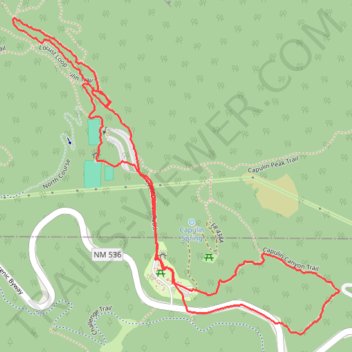
Loop Hike near Capulin in Cibola National Forest
- Distance: 3.5 Km
- Elevation gain: 122 m
- Maximum elevation: 2,715 m
- Elevation loss: 122 m
- Minimum elevation: 2,627 m
- Moving time: 59 m 57 s
- Moving speed: 3.5 Km/h
- Maximum speed: 11.2 Km/h
- Total time: 1 h 22 m
- Global speed: 2.6 Km/h
Interactive trail map
Trail profile
- Distance: 3.5 Km
- Elevation gain: 122 m
- Maximum elevation: 2,715 m
- Elevation loss: 122 m
- Minimum elevation: 2,627 m
- Moving time: 59 m 57 s
- Moving speed: 3.5 Km/h
- Maximum speed: 11.2 Km/h
- Total time: 1 h 22 m
- Global speed: 2.6 Km/h
About this trail
Name: Loop Hike near Capulin in Cibola National Forest trail, distance, elevation, map, profile, GPS track
Start: Capulin Picnic Ground, Bernalillo County, New Mexico, United States (35.21616 -106.41580)
End: Capulin Picnic Ground, Bernalillo County, New Mexico, United States (35.21616 -106.41587)
Coordinates: 35.21485 -106.42082 35.22289 -106.41071
Other hiking, mountain biking, running and outdoor activity trails
Click on a trail to view its statistics, map and profile.
Challenge Trail
United States > New Mexico > Bernalillo County
Distance: 22.9 Km • Elevation gain: 243 m • Maximum elevation: 3,244 m
Northcourse and Capulin Peak
United States > New Mexico > Bernalillo County
Distance: 6.4 Km • Elevation gain: 124 m • Maximum elevation: 3,037 m