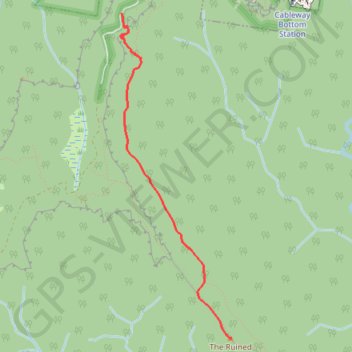
The Ruined Castle - Blue Mountains National Park
- Distance: 4.1 Km
- Elevation gain: 154 m
- Maximum elevation: 947 m
- Elevation loss: 329 m
- Minimum elevation: 718 m
Interactive trail map
Trail profile
- Distance: 4.1 Km
- Elevation gain: 154 m
- Maximum elevation: 947 m
- Elevation loss: 329 m
- Minimum elevation: 718 m
About this trail
Name: The Ruined Castle - Blue Mountains National Park trail, distance, elevation, map, profile, GPS track
Coordinates: -33.76346 150.28236 -33.73440 150.29419
Topography: Sydney topographic map, elevation, terrain
Other hiking, mountain biking, running and outdoor activity trails
Click on a trail to view its statistics, map and profile.
Mount Solitary - Kedumba Valley
Australia > New South Wales > Sydney > Katoomba
Blue Mountains National Park. #Hiking #Loop #BlueMountains
Distance: 35.0 Km • Elevation gain: 2,492 m • Maximum elevation: 983 m
Six Foot Track
Australia > New South Wales > Sydney > Katoomba
Hike / Bike. Kanagra-Boyd National Park. #Hiking #Bike #KanagraBoyd
Distance: 44.9 Km • Elevation gain: 1,583 m • Maximum elevation: 1,206 m
Splendour Rock to Katoomba
Distance: 22.5 Km • Elevation gain: 934 m • Maximum elevation: 1,064 m