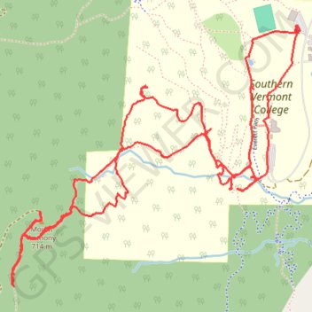
Mount Anthony from Southern Vermont College
- Distance: 7.9 Km
- Elevation gain: 480 m
- Maximum elevation: 708 m
- Elevation loss: 481 m
- Minimum elevation: 283 m
- Moving time: 2 h 10 s
- Moving speed: 4.0 Km/h
- Maximum speed: 17.9 Km/h
- Total time: 2 h 1 m
- Global speed: 3.9 Km/h
Interactive trail map
Trail profile
- Distance: 7.9 Km
- Elevation gain: 480 m
- Maximum elevation: 708 m
- Elevation loss: 481 m
- Minimum elevation: 283 m
- Moving time: 2 h 10 s
- Moving speed: 4.0 Km/h
- Maximum speed: 17.9 Km/h
- Total time: 2 h 1 m
- Global speed: 3.9 Km/h
About this trail
Name: Mount Anthony from Southern Vermont College trail, distance, elevation, map, profile, GPS track
End: Mansion Drive, Bennington, Bennington County, Vermont, United States (42.87228 -73.21706)
Coordinates: 42.86082 -73.23409 42.87228 -73.21688