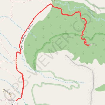
Dry Creek Road to Devil's Bridge in Coconino National Forest
This is a popular hike offering a beautiful payoff at the top with views of Sedona's iconic red rock formations. Though the trail starts off easy, it gradually becomes more challenging with a steep, rocky climb toward the sandstone arch, making sturdy footwear a must. Despite the crowds, the experience is well worth it for the unique vantage point from the arch. #Hiking #Mountain #Rock #Nature #Forest
- Distance: 6.3 Km
- Elevation gain: 159 m
- Maximum elevation: 1,520 m
- Elevation loss: 160 m
- Minimum elevation: 1,406 m
- Moving time: 1 h 39 m
- Moving speed: 3.8 Km/h
- Maximum speed: 5.5 Km/h
- Total time: 2 h 19 m
- Global speed: 2.7 Km/h
Interactive trail map
Trail profile
- Distance: 6.3 Km
- Elevation gain: 159 m
- Maximum elevation: 1,520 m
- Elevation loss: 160 m
- Minimum elevation: 1,406 m
- Moving time: 1 h 39 m
- Moving speed: 3.8 Km/h
- Maximum speed: 5.5 Km/h
- Total time: 2 h 19 m
- Global speed: 2.7 Km/h
About this trail
Name: Dry Creek Road to Devil's Bridge in Coconino National Forest trail, distance, elevation, map, profile, GPS track
Start: Dry Creek Road, Sedona, Yavapai County, Arizona, 86336, United States (34.89002 -111.81978)
End: Dry Creek Road, Sedona, Yavapai County, Arizona, 86336, United States (34.89006 -111.81983)
Coordinates: 34.89002 -111.81983 34.90304 -111.80776
Other hiking, mountain biking, running and outdoor activity trails
Click on a trail to view its statistics, map and profile.
Devil's Bridge from Mescal Trailhead via Chuckwagon Trail and Devil's Bridge Trail in Coconino National Forest
United States > Arizona > Yavapai County
Devil's Bridge Trail offers a scenic desert hike through the iconic red rocks of Sedona. The route is fairly easy until the last section, where a short but steep climb adds a bit of a challenge before reaching the impressive natural arch. The payoff at the top, with expansive views and the chance to stand on…
Distance: 6.5 Km • Elevation gain: 163 m • Maximum elevation: 1,521 m