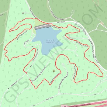
White Bison Loop Trail in Lone Elk County Park
The White Bison Loop Trail offers a scenic and relatively easy hike through a mix of wooded areas and open spaces. Along the route, hikers can enjoy views of the serene Lone Elk Lake, the surrounding oak and hickory forests, and abundant wildlife, including elk and deer, which are often seen near the trail. Whether visiting in the fall, when the foliage is particularly vibrant, or in other seasons, the trail provides a peaceful nature escape with the opportunity to observe a variety of local flora and fauna. #Hiking #Loop #Lake #Forest #Nature
- Distance: 4.9 Km
- Elevation gain: 118 m
- Maximum elevation: 188 m
- Elevation loss: 112 m
- Minimum elevation: 147 m
- Moving time: 1 h 27 m
- Moving speed: 3.4 Km/h
- Maximum speed: 8.5 Km/h
- Total time: 1 h 28 m
- Global speed: 3.3 Km/h
Interactive trail map
Trail profile
- Distance: 4.9 Km
- Elevation gain: 118 m
- Maximum elevation: 188 m
- Elevation loss: 112 m
- Minimum elevation: 147 m
- Moving time: 1 h 27 m
- Moving speed: 3.4 Km/h
- Maximum speed: 8.5 Km/h
- Total time: 1 h 28 m
- Global speed: 3.3 Km/h
About this trail
Name: White Bison Loop Trail in Lone Elk County Park trail, distance, elevation, map, profile, GPS track
Start: Park Road, Morschels, Saint Louis County, Missouri, 63021, United States (38.53126 -90.54342)
Coordinates: 38.52983 -90.54619 38.53656 -90.53416