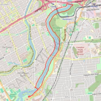
Loop Walk - Rideau River
Canada, ON, Ottawa
- Distance: 9.1 Km
- Elevation gain: 44 m
- Maximum elevation: 65 m
- Elevation loss: 45 m
- Minimum elevation: 56 m
- Moving time: 1 h 44 m
- Moving speed: 5.2 Km/h
- Maximum speed: 6.0 Km/h
- Total time: 1 h 47 m
- Global speed: 5.1 Km/h
Interactive trail map
Trail profile
- Distance: 9.1 Km
- Elevation gain: 44 m
- Maximum elevation: 65 m
- Elevation loss: 45 m
- Minimum elevation: 56 m
- Moving time: 1 h 44 m
- Moving speed: 5.2 Km/h
- Maximum speed: 6.0 Km/h
- Total time: 1 h 47 m
- Global speed: 5.1 Km/h
About this trail
Name: Loop Walk - Rideau River trail, distance, elevation, map, profile, GPS track
Coordinates: 45.38638 -75.68204 45.41650 -75.66135
Other hiking, mountain biking, running and outdoor activity trails
Click on a trail to view its statistics, map and profile.
Brockville - Ottawa
Canada > Ontario > Brockville > Brockville
#Bike #Brockville #Ottawa
Distance: 118.4 Km • Elevation gain: 375 m • Maximum elevation: 134 m
Walk - Rideau Canal
Canada, ON, Ottawa
Distance: 4.6 Km • Elevation gain: 25 m • Maximum elevation: 72 m