Thank you for supporting this site ❤️
Make a donation
Make a donation
Gear up for your next adventure:
As an Amazon Associate, this site earns from qualifying purchases at no extra cost to you.
Cheesequake State Park
- Distance: 5.2 Km
- Elevation gain: 48 m
- Maximum elevation: 21 m
- Elevation loss: 46 m
- Minimum elevation: 1 m
- Moving time: 1 h 28 m
- Moving speed: 3.5 Km/h
- Maximum speed: 6.7 Km/h
- Total time: 2 h 27 m
- Global speed: 2.1 Km/h
Interactive trail map
Thank you for supporting this site ❤️
Make a donation
Make a donation
Gear up for your next adventure:
As an Amazon Associate, this site earns from qualifying purchases at no extra cost to you.
Trail profile
- Distance: 5.2 Km
- Elevation gain: 48 m
- Maximum elevation: 21 m
- Elevation loss: 46 m
- Minimum elevation: 1 m
- Moving time: 1 h 28 m
- Moving speed: 3.5 Km/h
- Maximum speed: 6.7 Km/h
- Total time: 2 h 27 m
- Global speed: 2.1 Km/h
Thank you for supporting this site ❤️
Make a donation
Make a donation
Gear up for your next adventure:
As an Amazon Associate, this site earns from qualifying purchases at no extra cost to you.
About this trail
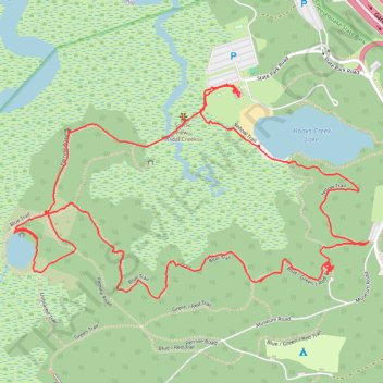
Name: Cheesequake State Park trail, distance, elevation, map, profile, GPS track
Coordinates: 40.43458 -74.27858 40.44057 -74.26554
Thank you for supporting this site ❤️
Make a donation
Make a donation
Gear up for your next adventure:
As an Amazon Associate, this site earns from qualifying purchases at no extra cost to you.