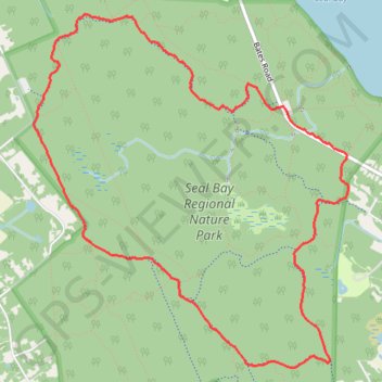
Import a GPX file

Seal Bay Loop

  • Distance: 8.6 Km
  • Elevation gain: 96 m
  • Maximum elevation: 110 m
  • Elevation loss: 96 m
  • Minimum elevation: 58 m

Interactive trail map

Trail profile

  • Distance: 8.6 Km
  • Elevation gain: 96 m
  • Maximum elevation: 110 m
  • Elevation loss: 96 m
  • Minimum elevation: 58 m

About this trail

Other hiking, mountain biking, running and outdoor activity trails

Click on a trail to view its statistics, map and profile.

Fanny Bay - Campbell River

Canada > British Columbia > Comox Valley Regional District > Area A (Baynes Sound)

Vancouver Island. #Bike #Fanny #Campbell #Vancouver

Distance: 79.1 Km • Elevation gain: 452 m • Maximum elevation: 93 m

Seal Bay Loop

Canada > British Columbia > Comox Valley Regional District > Area B (Lazo North)

Seal Bay Regional Nature Park. Vancouver Island. #Hiking #Bike #MTB #Horse #Loop #SealBay #Vancouver

Distance: 8.6 Km • Elevation gain: 99 m • Maximum elevation: 110 m

Gear up for your next adventure:

🥤Hydration Packs - Hydration systems for hiking
🔥Camping Stoves - Portable stoves for outdoor cooking
🐍Australian Snake Bite Kits - Specific pressure immobilization bandages for Australian venomous snakes
👣Snake & Scrub Gaiters - Protection against spinifex, mud, and snakes while walking off-track
📟Satellite Messengers - Two-way satellite communication to stay in touch beyond the cellular grid

As an Amazon Associate, this site earns from qualifying purchases at no extra cost to you.