Thank you for supporting this site ❤️
Make a donation
Make a donation
Gear up for your next adventure:
As an Amazon Associate, this site earns from qualifying purchases at no extra cost to you.
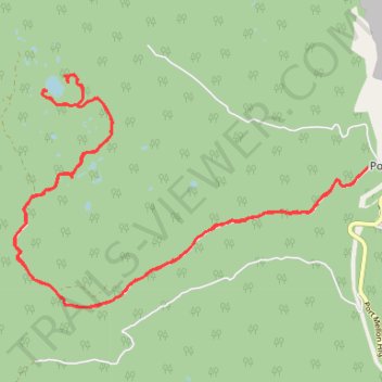
Hike to Claire Lake
- Distance: 20.3 Km
- Elevation gain: 1,059 m
- Maximum elevation: 996 m
- Elevation loss: 1,059 m
- Minimum elevation: 57 m
- Moving time: 4 h 25 m
- Moving speed: 4.6 Km/h
- Maximum speed: 8.8 Km/h
- Total time: 5 h 2 m
- Global speed: 4.0 Km/h
Interactive trail map
Thank you for supporting this site ❤️
Make a donation
Make a donation
Gear up for your next adventure:
As an Amazon Associate, this site earns from qualifying purchases at no extra cost to you.
Trail profile
- Distance: 20.3 Km
- Elevation gain: 1,059 m
- Maximum elevation: 996 m
- Elevation loss: 1,059 m
- Minimum elevation: 57 m
- Moving time: 4 h 25 m
- Moving speed: 4.6 Km/h
- Maximum speed: 8.8 Km/h
- Total time: 5 h 2 m
- Global speed: 4.0 Km/h
Thank you for supporting this site ❤️
Make a donation
Make a donation
Gear up for your next adventure:
As an Amazon Associate, this site earns from qualifying purchases at no extra cost to you.
About this trail
Name: Hike to Claire Lake trail, distance, elevation, map, profile, GPS track
Coordinates: 49.49789 -123.56251 49.52403 -123.50132
Thank you for supporting this site ❤️
Make a donation
Make a donation
Gear up for your next adventure:
As an Amazon Associate, this site earns from qualifying purchases at no extra cost to you.