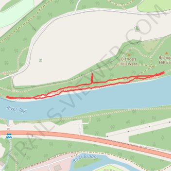
Track of the split tracks 😅
- Distance: 1.1 Km
- Elevation gain: 17 m
- Maximum elevation: 68 m
- Elevation loss: 18 m
- Minimum elevation: 55 m
- Moving time: 16 m 55 s
- Moving speed: 4.0 Km/h
- Maximum speed: 5.5 Km/h
- Total time: 16 m 55 s
- Global speed: 4.0 Km/h
Interactive trail map
Trail profile
- Distance: 1.1 Km
- Elevation gain: 17 m
- Maximum elevation: 68 m
- Elevation loss: 18 m
- Minimum elevation: 55 m
- Moving time: 16 m 55 s
- Moving speed: 4.0 Km/h
- Maximum speed: 5.5 Km/h
- Total time: 16 m 55 s
- Global speed: 4.0 Km/h
About this trail
Name: Track of the split tracks 😅 trail, distance, elevation, map, profile, GPS track
Start: A9, Inver, Perth and Kinross, Scotland, PH8 0JR, United Kingdom (56.56401 -3.59280)
End: A9, Inver, Perth and Kinross, Scotland, PH8 0JR, United Kingdom (56.56399 -3.59275)
Coordinates: 56.56323 -3.60112 56.56401 -3.59275
Other hiking, mountain biking, running and outdoor activity trails
Click on a trail to view its statistics, map and profile.
Falls of the Braan and River Tay loop trail
United Kingdom > Scotland > Perth and Kinross > Dunkeld > Inchmagrannachan
Distance: 10.9 Km • Elevation gain: 234 m • Maximum elevation: 186 m
Walk over A9 bridge over River Braan by pedestrian pavement (sidewalk) and small diversion for SGN gas pipeline route then Fiddlers path
United Kingdom > Scotland > Perth and Kinross > Dunkeld
Distance: 6.0 Km • Elevation gain: 79 m • Maximum elevation: 76 m
EMTB Gravel: Murthly - Birnam - Loop
United Kingdom > Scotland > Perth and Kinross > Newlands
Around Dunkeld, Perthshire Scotland
Distance: 46.4 Km • Elevation gain: 869 m • Maximum elevation: 305 m