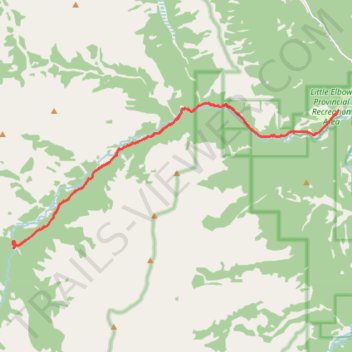
Little Elbow to Mount Romulus Campground
- Distance: 24.8 Km
- Elevation gain: 371 m
- Maximum elevation: 1,811 m
- Elevation loss: 371 m
- Minimum elevation: 1,612 m
- Moving time: 3 h 56 m
- Moving speed: 6.3 Km/h
- Maximum speed: 20.3 Km/h
- Total time: 4 h 19 m
- Global speed: 5.7 Km/h
Interactive trail map
Trail profile
- Distance: 24.8 Km
- Elevation gain: 371 m
- Maximum elevation: 1,811 m
- Elevation loss: 371 m
- Minimum elevation: 1,612 m
- Moving time: 3 h 56 m
- Moving speed: 6.3 Km/h
- Maximum speed: 20.3 Km/h
- Total time: 4 h 19 m
- Global speed: 5.7 Km/h
About this trail
Name: Little Elbow to Mount Romulus Campground trail, distance, elevation, map, profile, GPS track
Coordinates: 50.75876 -114.98851 50.79663 -114.85399
Other hiking, mountain biking, running and outdoor activity trails
Click on a trail to view its statistics, map and profile.
Little Elbow to Big Elbow Campground
Canada > Alberta > Kananaskis Improvement District
Distance: 18.4 Km • Elevation gain: 195 m • Maximum elevation: 1,729 m
12-OCT-21 16:57:46
Canada > Alberta > Kananaskis Improvement District
Distance: 26.5 Km • Elevation gain: 1,078 m • Maximum elevation: 2,329 m