Import a GPX file

Salmon Pools (Sentier Trous de Saumon)

  • Distance: 9.9 Km
  • Elevation gain: 170 m
  • Maximum elevation: 71 m
  • Elevation loss: 178 m
  • Minimum elevation: 15 m
  • Moving time: 2 h 6 m
  • Moving speed: 4.7 Km/h
  • Maximum speed: 37.0 Km/h
  • Total time: 2 h 21 m
  • Global speed: 4.2 Km/h

Interactive trail map

Trail profile

  • Distance: 9.9 Km
  • Elevation gain: 170 m
  • Maximum elevation: 71 m
  • Elevation loss: 178 m
  • Minimum elevation: 15 m
  • Moving time: 2 h 6 m
  • Moving speed: 4.7 Km/h
  • Maximum speed: 37.0 Km/h
  • Total time: 2 h 21 m
  • Global speed: 4.2 Km/h

About this trail
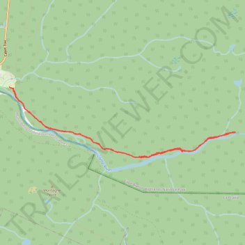
Name: Salmon Pools (Sentier Trous de Saumon) trail, distance, elevation, map, profile, GPS track

Start: Roberts Brook Road, Cape Breton Highlands National Park, Inverness County, Nova Scotia, Canada (46.64341 -60.94669)

End: 37639, Cabot Trail, Cape Breton Highlands National Park, Inverness County, Nova Scotia, Canada (46.64355 -60.94778)

Coordinates: 46.63208 -60.94778 46.64355 -60.89389

Gear up for your next adventure:

📦Crushproof Equipment Cases - Safe transport for sensitive surveying and mapping instruments
🧤Thermal Hiking Gloves - Keep your hands warm and functional during high-altitude winter treks
🪑Portable Backpacking Chairs - A comfortable seat for studying maps at the end of the day
🦶Orthotic Hiking Insoles - Extra arch support for long-distance topographic treks
🧼Biodegradable Outdoor Soap - Clean gear and yourself without harming the local ecosystem

As an Amazon Associate, this site earns from qualifying purchases at no extra cost to you.