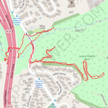
Leona Heights short fire trail hike
Oakland Walking
- Distance: 3.0 Km
- Elevation gain: 129 m
- Maximum elevation: 156 m
- Elevation loss: 129 m
- Minimum elevation: 95 m
- Moving time: 46 m 23 s
- Moving speed: 3.9 Km/h
- Maximum speed: 20.0 Km/h
- Total time: 1 h 1 m
- Global speed: 2.9 Km/h
Interactive trail map
Trail profile
- Distance: 3.0 Km
- Elevation gain: 129 m
- Maximum elevation: 156 m
- Elevation loss: 129 m
- Minimum elevation: 95 m
- Moving time: 46 m 23 s
- Moving speed: 3.9 Km/h
- Maximum speed: 20.0 Km/h
- Total time: 1 h 1 m
- Global speed: 2.9 Km/h
About this trail
Name: Leona Heights short fire trail hike trail, distance, elevation, map, profile, GPS track
Coordinates: 37.79004 -122.18150 37.79265 -122.17533
Other hiking, mountain biking, running and outdoor activity trails
Click on a trail to view its statistics, map and profile.