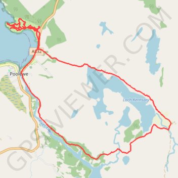
Inverewe and Great Wilderness
- Distance: 15.6 Km
- Elevation gain: 308 m
- Maximum elevation: 47 m
- Elevation loss: 308 m
- Minimum elevation: 1 m
- Moving time: 4 h 19 m
- Moving speed: 3.6 Km/h
- Maximum speed: 18.8 Km/h
- Total time: 5 h 49 m
- Global speed: 2.7 Km/h
Interactive trail map
Trail profile
- Distance: 15.6 Km
- Elevation gain: 308 m
- Maximum elevation: 47 m
- Elevation loss: 308 m
- Minimum elevation: 1 m
- Moving time: 4 h 19 m
- Moving speed: 3.6 Km/h
- Maximum speed: 18.8 Km/h
- Total time: 5 h 49 m
- Global speed: 2.7 Km/h
About this trail
Name: Inverewe and Great Wilderness trail, distance, elevation, map, profile, GPS track
Start: A832, Poolewe, Highland, Scotland, IV22 2LG, United Kingdom (57.77502 -5.59650)
End: A832, Poolewe, Highland, Scotland, IV22 2LH, United Kingdom (57.77502 -5.59665)
Coordinates: 57.74725 -5.60887 57.77752 -5.54240