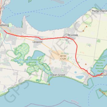
Geelong - Queenscliff
#Bike
- Distance: 34.8 Km
- Elevation gain: 176 m
- Maximum elevation: 83 m
- Elevation loss: 191 m
- Minimum elevation: 0 m
Interactive trail map
Trail profile
- Distance: 34.8 Km
- Elevation gain: 176 m
- Maximum elevation: 83 m
- Elevation loss: 191 m
- Minimum elevation: 0 m
About this trail
Name: Geelong - Queenscliff trail, distance, elevation, map, profile, GPS track
Coordinates: -38.27136 144.36419 -38.16238 144.66198
Topography: Geelong topographic map, elevation, terrain
Other hiking, mountain biking, running and outdoor activity trails
Click on a trail to view its statistics, map and profile.